Warren County Gis Request - Warren County, Ohio
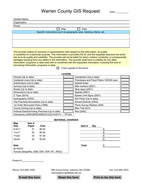
Warren County Gis Request is a legal document that was released by the Geographical Information System - Warren County, Ohio - a government authority operating within Ohio. The form may be used strictly within Warren County.
FAQ
Q: What is a GIS request?
A: A GIS request is a request for information or data related to the Warren County, Ohio geographic information system.
Q: What is GIS?
A: GIS stands for Geographic Information System. It is a system designed to capture, store, analyze, manage, and present spatial or geographic data.
Q: What kind of information can I request through the Warren County GIS?
A: You can request various types of geographic information through the Warren County GIS, such as maps, property information, land use data, and more.
Q: How long does it take to process a GIS request in Warren County?
A: The processing time for a GIS request in Warren County may vary depending on the nature of the request and the workload of the GIS department. It is advisable to contact the Warren County government for an estimated timeline.
Form Details:
- The latest edition currently provided by the Geographical Information System - Warren County, Ohio;
- Ready to use and print;
- Easy to customize;
- Compatible with most PDF-viewing applications;
- Fill out the form in our online filing application.
Download a fillable version of the form by clicking the link below or browse more documents and templates provided by the Geographical Information System - Warren County, Ohio.